

 4.9 nodi km/h SW
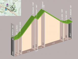
This Cyclotour starts and finishes in Morgex. This circuit is harder than the Courmayeur Cyclotour with a distance of 31.5km and a total elevation of 980m.
The Cyclotour passes through the following towns:
- Morgex - the beginning of the route at an altitude of 928m
- La Ruine - at the 2nd km at 926m altitude
- La Salle - at 3.8 km at 1009m altitude
- Challancin - at 10.9 km at 1589m altitude
- Cheverel - at 12.4km at 1487m altitude
- Planaval - at 16.1 km at 1736m altitude
- La Salle - at 26.1 km at 1009m altitude
- Le Pont - at 28.5km at 915m altitude
- Morgex - end of the route at an altitude of 928m